The Eye of the Sahara — a 50-kilometer blue-ringed bull's-eye in the Mauritanian desert visible from space, carved over hundreds of millions of years, and once proposed by some as the lost location of Atlantis.
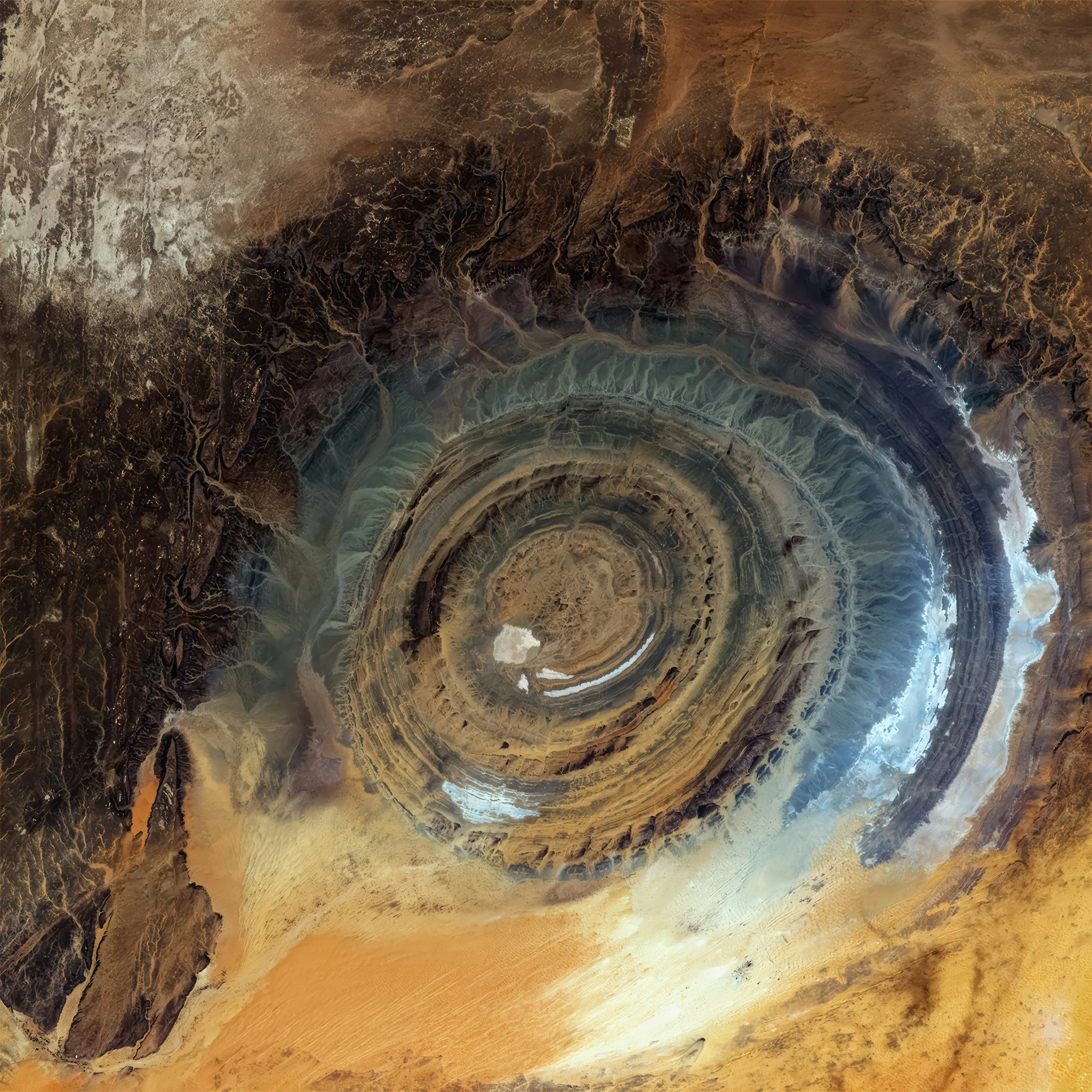
Seen from orbit, the Richat Structure appears as a perfectly concentric target drawn on the surface of the Sahara — a 50-kilometer eye in the desert, its rings of exposed rock alternating in tone from pale to dark, centered on a dome ringed by successive ridges. Astronauts on early space missions used it as a navigational landmark because nothing else in the surrounding thousand kilometers of flat desert even remotely resembles it. The structure's image from the International Space Station has been reproduced in hundreds of geography textbooks. From the ground, it looks like nothing in particular.
The Richat Structure — also called the Eye of the Sahara or Guelb er Richât — is located in the Adrar Plateau of Mauritania, in some of the most remote and least-visited desert on Earth. At ground level, standing inside the formation, its scale is too large to read. What the eye sees is low rocky ridges, gravel plains, the occasional scrubby vegetation. The full concentric geometry becomes visible only from altitude, its rings spanning approximately 50 kilometers in diameter — one of the largest individual geological structures visible to the naked eye from space.
For decades after its aerial discovery in the mid-20th century, geologists assumed the Richat Structure was a meteorite impact crater. The concentric ring pattern is a recognizable signature of large impactor strikes. Subsequent investigation found no supporting evidence: no shocked quartz, no unusual chemical signatures at depth, no preserved impactor material. The current scientific consensus holds that the structure formed through a combination of geological uplift and differential erosion. An ancient dome of sedimentary rock was pushed upward by magmatic intrusion from below. Over hundreds of millions of years, the dome eroded inward — more resistant rock layers remaining as ridges, softer material washing away as low-lying plains. The concentric pattern is a cross-section of geological time exposed at the surface.
The Atlantis theory attached to the Richat Structure in the 2010s and has not let go. The formation's diameter of approximately 23 kilometers at its central core is cited by proponents as matching Plato's description of Atlantis's ringed city with suspicious precision. The surrounding region was covered by a shallow sea in the distant geological past. Mainstream science is dismissive — the timeline, the material evidence, and the geography all present serious problems for the hypothesis. But the theory circulates with a persistence that suggests it satisfies a desire that geological explanations alone do not.
The nearest settlement is Ouadane, a former Saharan caravan trading post that is itself a UNESCO World Heritage Site. The Richat Structure is reached by Land Rover across approximately 50 kilometers of open desert. Most researchers and photographers arrive by small aircraft. From 3,000 meters, the structure announces itself with unmistakable authority — a thing so large and so geometrically precise that the argument about its origin becomes, briefly, secondary to the fact of its existence.